Very kind of you to offer the PointPerfect remainder of the trial month you have, but I've not yet got any RTK boards as yet, and will await to do some more reading up on the latest info before thinking of buying anything.
My bot is not a mowing bot, its main function was to simply be sent on regular patrols to deter the rabbits that like to chew on some of my wife's plants and dig little holes on the lawn. RTK holds out the possibility of an accurate way to pinpoint the bots location, and coupled with a compass sensor and a means of indicating where it should currently be heading to, such as ArduRover or some other home brewed solution, it can be sent along its merry way. Of course. before the bot is allowed to trundle freely about, other sensors to detect obstacles that it may encounter along its route will need to be tested and found fit for purpose.
Other thoughts for the bot are to have a camera mounted so that the bot could be directed to a desired located to stream back video and to have some sort of docking station where it could automatically get its batteries recharges.
The bot will only be used in the vicinity of my property and I have quite good wifi coverage for my test area and will extend it as required so my communication from base to bot is catered for. Right now its something I sporadically have a play with, and as said, I've been having some success with just using GPS, but its early days. I follow your project with interest, but my attempts will follow along at a rather leisurely pace.
I have a question that might sound halfcocked! 🤔 This is ignorance and old knowledge talking, so take with a grain of salt (or tell me where my logic falls apart). But to show that I do have some basis for my question and an interest.
Background
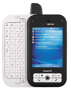
Before iPhone and Android, I did a project on Windows Mobile in the early 2000's. It was a cheap race car telemetry system. One of the last devices I used (before iPhone) killed the project was a PocketPC by HTC.
Aside - It's a wonder that the short-sighted Microsoft people had a seven year lead on iPhone and the best they could do was cram the desktop Windows UI on a phone.
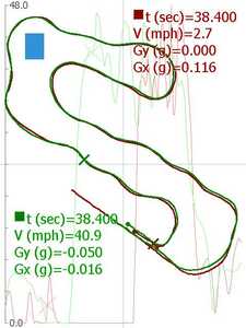
Anyway, the phones had no sensors. I found a Bluetooth GPS antenna that could do 10Hz. Just using the positional data points (not the velocity data available) the phone would do real-time plotting the position, calculate the velocity and accelerations of race car on the track. In the sample two laps, you can see the plot of the race and dimly in the background are the velocity and acceleration graphs. I used no external GPS or other base stations. The phone and GPS module were all that was needed.
Definition of Problem
The biggest problem as you all are touching on is the accuracy of the GPS data. Actually, even in the early 2000's with a commodity Bluetooth GPS module, I was getting excellent accuracy. I dare say it was down in the single-digit inches range. The stated accuracy back then of 32 feet was because of one of the satellites going out of range or a new one coming into range. The module would get say 10 satellites at any one time. But as some satellites fall off and others come on, the average of the satellites could and did shift suddenly by multiple feet. It really was a simple matter of maintaining a relative offset during the race. We knew that the car didn't suddenly teleport 30 feet to the left, so we simply set a new offset and normalized the data to the original baseline until the next satellite shift. We could also keep a list of satellites and could note when one went off / came on the list and thus expect a Shift.
In the practical Race Car problem, we could compare data and estimate where the driver could stay on the throttle longer or delay the breaking longer. Lap times came down. With experience, the idea was, to plot a theoretical perfect lap and identify throttle and breaking zones.
I'm wondering if something like this Moving Offset could be used on the mower concept. I think if you plot the data, you'll see the sudden position changes. Mowers don't teleport either. 😆 I think the main dependency of concept is the 10Hz sample rate. You can easily decide what is the maximum distance that the mower can move in 1/10th of a second. I would assume after twenty years, the GPS modules can do at least that good.
But the Question...
Knowing that all GPS is... are a bunch of satellites sending down a synchronized atomic clock's time. Our phones take these times and do the triangulation calculations and determine your location. Instead of buying expensive equipment and/or getting these subscription services, would it be possible to make a base unit with things we readily get in the DIY Arduino world? I'd think a dirt-cheap GPS can get us the atomic clock time as a baseline. It'd only need to get it a boot time. Then using the GPS radio frequency, broadcast the time beacon. I'd think the transmitter would be down in the micro-watt range. Put the sensor/transmitter on a pole, add some battery equipment and make our own super accurate Corrector system. What am I missing?
3 lines of code = InqPortal = Complete IoT, App, Web Server w/ GUI Admin Client, WiFi Manager, Drag & Drop File Manager, OTA, Performance Metrics, Web Socket Comms, Easy App API, All running on ESP8266...
Even usable on ESP-01S - Quickest Start Guide
Its all a matter of how accurate one needs to be. GPS is quite good, it does as you say, triangulate based on the satellites is sees. It can be seemingly quite accurate, but it accuracy is stated to be about 5 metres. This is quite good enough for vehicle sat nav's with a clever algorithm to match this to a road map, and to show a blob on the road your vehicle is on, but maybe not so good at getting a bot through a gate 3 meters wide, where it may end up with an argument with the gate post.
The idea of a base station and RTK is that the bot has the GPS on board but there is also a stationary base station in a fixed position and calibrated to the precise co-ordinates. As the satellites drift in an out it calculates the drift and this is transmitted to the bot based GPS which can then compensate to give 1cm accuracy This base station may be one of your own, or one provided by a third party service that sends the correction data to you (for which they would like a modest fee).
So if its a matter of a yard or so, GPS is fine, it its an inch, you pays your money or takes your chances. Often plain old GPS gives good results, just make sure your bots sensors can recognise a looming gate post 😀.
I'm having a play with a plain old GPS as a base station and calculating the initial difference from a google earth coordinates and seeing how this differs over time. The on-going difference can then be sent to the on board bot just as RTK does. Probably I wont get inch accuracy, but if I get six inches, well, whats six inches between a man and his bot, I'm sure that would be enough to keep a smile on the bots face.


